UN Agency Publishes “Peatland Mapping and Monitoring Guidelines”
May 6, 2020
Note: Please be aware that links on this page take you to third party websites.
The FAO (Food & Agriculture Organisation), a United Nations agency, has launched “Peatland Mapping and Monitoring Guidelines”, a practical publication that provides technical information about the world’s peatlands and recommendations on how to manage them properly.
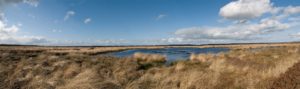
Peatlands cover only 3% of the earth’s surface, but they store as much carbon as all of the world’s vegetation. These fragile locations have accumulated carbon over thousands of years, but around 15% of the world’s peatlands have been drained for various reasons. Allowing them to dry out, or cutting and removing peat from them, releases the stored carbon into the atmosphere. Preserving peatlands and making sure they remain healthy allows them to grow and store additional carbon.
The FAO Peatland Mapping and Monitoring guidelines and online tool help member states to map peatlands. This in turn helps scientists to monitor water levels on the peat – vital to maintaining healthy peat bogs – and indicates when action is needed to protect the peat.
You can read the UN announcement here: https://news.un.org/en/story/2020/03/1059632
You can find the FAO article here: http://www.fao.org/news/story/en/item/1265487/icode/?platform=hootsuite